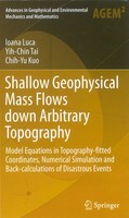
Shallow Geophysical Mass Flows down Arbitrary Topography

Shallow Geophysical Mass Flows down Arbitrary topography
Yih-Chin Tai
Department of Hydraulic and Ocean Engineering
National Cheng Kung University
Springer-Verlag, 2016, ISBN 978-3-319-02626-8, ISBN 978-3-319-02627-5 (eBook)
Abstract
The global climate change and the resulted extreme weather conditions have substantially affected the type of precipitation. The long duration of abnormal heavy rainfall might induce the sediment-related hazardous flows, such as debris flows or landslides in different scales, by which severe hazardous consequences in the mountain area have been reported frequently. A powerful and efficient simulation tool for describing the flow behavior as well as for the theoretical prediction of the impacting zones are highly requested not only by the scientific or engineering community but also by the personnel in civil services.
This book summarizes researches on gravity driven avalanching flows down arbitrary mountain topography. The aims and scopes are ambitious as follows:
(i) Development of the governing equations (balances of mass and momentum) embedded in the terrain-following coordinate system;
(ii) The numerical implementation of numerical the proposed models and their application to simple academic laboratory chute experiments;
(iii) The demonstration that such models can reproduce with sufficient accuracy real landslide events (an earthquake and typhoon induced landslide in Taiwan).
All three parts of the book are informative and establish together a holistic understanding of the complexities of gravity driven mass flows and thus enrich our scientific understanding of such processes to the benefit of our scientific understanding of processes in avalanche prone territory.
The readership will be from geophysics, geology, geomorphology, civil and environmental engineering, geophysical fluid mechanics, applied physics and numerical mathematics. Graduate students, researchers or personnel in civil services in these fields are addressed.
氣候變遷,全球天災不斷,極端降雨事件頻傳,其所誘發之山崩、土石流帶來難以承受的嚴重損害。公部門、學術界或是工程單位都希望能建立一套有效且方便的「現地地形災害流體理論模型」來搭配「數值模擬」系統,用於潛勢災害評估(包括 事件過程的模擬重現、災害程度、影響範圍多寡 等風險的評估)。此書主要著眼點在於「現地地形災害流體理論模型」並整合相關「數值模擬」應用的專業書籍不多;此書將近年來相關研究領域的理論發展、現地資料與數據,以及相關的模擬應用等做一次有系統的整理並完整介紹,期待能夠在這相關研究以及工程應用領域盡一點心力。
本書主要區分為三個主題:(一)、在現在地形座標上理論模型的建立;(二)、數值方法的介紹、理論模型特性的呈現以及相關的實驗驗證;(三)、實際案例的應用與探討。對於其主要工作的範圍在 地球物理、地質、地形地貌、土木、環工 等與災害流體相關研究領域的工程或是研究人員有相當助益。


